
Before we begin placing continents, we need to refamiliarize ourselves with the nature and features of maps.
Latitude or meridians are lines or bands that run east-west around the globe. There are generally 12 to 24 segments or squares of latitude on most maps, with the easternmost area of Asia sharing a square with the westernmost part of Alaska, in a wrap-around. The primary line of latitude is the Equator, which is located halfway between the north and south poles, at 0 degrees latitude, dividing the world up into the north and south hemispheres, extending from 0 degrees latitude at the Equator to 90 degrees north latitude at the top of the north pole, and 90 degrees south latitude at the part of the south pole nearest the bottom of the map. The Equator is an abstraction representing the halfway point of the rotation of the Earth on its axis.
Longitude or parallels, are north-south lines or bands from the north to south poles. There are generally 6-12 squares of longitude on most maps, with the "top squares" containing most of the north pole, and the "bottom squares" containing most of the south pole/Antarctica. The primary line of longitude is the Prime Meridian at 0 degrees longitude, dividing the world into west and east hemispheres, extending from 0 degrees longitude to 180 degrees south longitude in the southernmost part of the south pole, and 180 degrees north longitude in the northernmost section of the north pole.

Most maps are orthographic or stereographic, the difference between the two essentially being that orthographic maps depict the Earth in a convex (bulging outward) shape, with their lines curved to visually aid this concept, while stereographic maps are more or less convex (collapsing inward), which doesn't help enforce the globe idea overall, but which more accurately depicts the significant curvature at the poles.
Types of Maps
There are many kinds of world maps, all non-globe ones being Projection Maps, which are 2D representations of our globe-shaped planet. The three main models or kinds of basic world maps of note for gaming,are listed below.
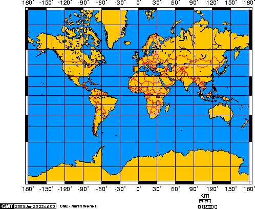
Gall/Mercator stereographic maps depict everything completely flat with straight latitude and longitude. They are the least accurate, as the shapes and general locations of the continents are consistent, but their distances and sizes are wrong, and they lack the curvature and deformations of the globe that result in real world latitude and longitude. These are, however, the easiest maps to make for non-scientific or game purposes, and the model this series will be using.
|

 |
| Robinson Map |
Winkel maps, now used predominately by National Geographic, are the most accurate 2d representations of our 3d globe, with significant deforming of the continents and longitude, though some Winkel maps maintain straight lines of latitude. These would be the most difficult to make for game purposes.
 |
| Winkel Map |
For the step of placing the continents, we're going to use a process encompassing underlying ideas of these maps and lines and divisions, resulting in a product most closely resembling a Mercator map.
The next section of this series will deal with visually creating random world maps using a free software graphics application called GIMP (similar to Adobe Photoshop but free), and is a pretty easy exercise - so easy it may surprise you how good your maps look. Directly after that portion is a section on placement of the continents you have generated from a graphics program. If you would rather skip creating visual representations of your continents, you should still read the "Placing the Continents" section below that, for tips more specifically aimed at the "logic" of the game world itself.
Next: How To Create Random World Maps With GIMP in 36 Easy Steps
No comments:
Post a Comment